Data is available for the following
local stations:
Location
Mean annual rainfall (mm)
Sunshine(hrs)
Mean temp (C)
Buxton (307m)
1232
1133
7.8
Huddersfield(232m)
1000
1130
8.8
Sheffield
(131m)
818
1300
9.5
Care must be taken when extrapolating
this data to Blackamoor because of the differences in altitude and location
in relation to the uplands of the Pennines.
The altitude of Blackamoor ranges
between c.230m to c.280in and the site has a generally easterly aspect.
Topography generally slopes south and east from high points in the north-east
and west. The main stream line, Blacka Dyke, flows west-cast through the
centre of the site, and creates a rather broad valley with Blacka Moor comprising
the northern 'ridge' and Blacka Hill the southern 'ridge'. The stream
flows into the nearby Oldhay Brook.
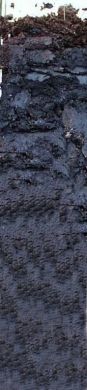
Rocks from the Lower Coal Measures
dominate the geology, in particular gritstones and shales. In the west
of the site (at Cowsick) a ridge of the locally termed Rough Rock (which also
underlies the adjacent Totley Moor) gives way to a sequence of shales which
are disrupted by two main faults. Several springs emerge in this area
(including include Blacka Dyke), together with flushes and bogs. Periglacial
head occurs in the east and south of the site and is the predominant material
over most of the lower slopes of Blacka Hill.
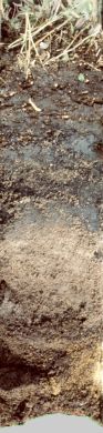
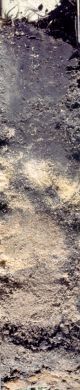
Soils range from podzols and
shallow peats on the more freely draining areas, to deeper peats and gleys
in permanently waterlogged areas. In the south (primarily in the woodland)
soils vary from podzols in areas of well-drained sandstones and grits,
to more base-rich substrates where head and shales are present. Modified
soils with an increased base-status are present alongside the roadway
where limestone chippings have been used as ballast.
For more information on soil
physical and chemical properties click here.